Introduction
When you hear the term Building Information Modeling (BIM), you might think of a vertical asset (such as a building) represented as a 3D digital twin. However, this isn’t always the case. A digital twin can come in many different forms and serve different functions. The BIM Dictionary defines a digital twin as:
A set of digital assets – models, documents and data sets - that mirror a physical Asset for part/whole of the Asset Life Cycle.
— BIM Dictionary1
The definition of what BIM is may also vary from person to person and has evolved over time, but the BIM Dictionary defines it as:
…a set of technologies, processes and policies enabling multiple stakeholders to collaboratively design, construct and operate a Facility in virtual space. In ISO 19650 part 1, BIM refers to the “use of a shared digital representation of a built Asset to facilitate design, construction and operation processes to form a reliable basis for decisions”
— BIM Dictionary2
So, there are processes availabile in BIM that can be used to manage information, and a digital twin can contain models, documents and datasets representing a physical asset during it’s life cycle. These are the principles that have been implemented on this road resurfacing project.
Project Details
The Tygerberg Hospital Road Resurfacing (Phase 2) project involved an investigation and remedial work for all the existing access roads, parking areas, walkways, road markings, road signs, as well as pedestrian and transport movement within the hospital’s property.
Approach
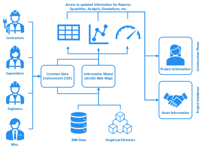
It was decided to use a BIM approach to manage the information and a GIS approach to serve as the Information Model, helping to manage the project. The Information Model was hosted on ArcGIS Online as a Web Map Application and linked to a cloud-based Common Data Environment (CDE), which combined formed the digital twin.
My Role and Experience
Working closely with the project manager, my role on the project included creating the GIS Information Model and setting up the field data collection capabilities using a mobile device. I was also responsible for the BIM Coordination between the contractor, project manager and site agent/field worker. This entailed managing information flows and providing training on the systems. Multiple Web Map Applications were created for various purposes, using Web App Builder, Dashboards and Experience Builder from ArcGIS. The field data was collected using ArcGIS Field Maps.
Although the model in this case is a 2D map of the project, for a road resurfacing project it may not always necessary to have it in 3D. This combined GIS and BIM approach proved very effective, saved a lot of time, increased collaboration and provided authoritative information to all stakeholders.
I created a Story Map to tell the tale more immersively, which is available in the next section.
Story Map
The Story Map is embedded below, however it is much better to view it in a new window from the link: https://arcg.is/15eX54
Useful links
For more information please have a look at the following links:
- ArcGIS Story Maps: https://doc.arcgis.com/en/arcgis-storymaps/get-started/what-is-arcgis-storymaps.htm
- ArcGIS Field Maps: https://www.esri.com/en-us/arcgis/products/arcgis-field-maps/overview
- ArcGIS Online: https://www.esri.com/en-us/arcgis/products/arcgis-online/overview
-
Digital twin definition from BIM Dictionary ↩︎
-
BIM definition from BIM Dictionary ↩︎